Around the world, it's become second nature for people to navigate their way through cities and streets via Google Maps, but now the tech giant has announced you'll soon be able to bring some of that power to indoor spaces as well.
The latest post on Google's blog lists a host of AI-powered updates that will be rolling out over the course of the year to Google Maps, and chief among them is an Indoor Live View.
- Google Maps will let you add new roads
- Google Maps aims to make finding things to do easier
- Google Maps gets universal Dark Mode
Google Maps has already implemented Live View for a while now – a feature which uses the company's wealth of Street View footage to determine specific directions and overlay them over live footage from your camera, creating an augmented reality (AR) directional tool.
Indoor Live View, as its name suggests, is the same feature but will also operate in a number of key indoor locations such as malls, airports, and other transit stations.
According to Google, this new feature "can help you find the nearest elevator and escalators, your gate, platform, baggage claim, check-in counters, ticket office, restrooms, ATMs and more," so it's clearly a granular tool.
As for availability, the feature is live now on both iOS and Android apps, but is currently only operating in "a number of malls in Chicago, Long Island, Los Angeles, Newark, San Francisco, San Jose, and Seattle," with locations in Tokyo and Zurich rolling out in the coming months and other cities further down the track.
Google Maps and the environment
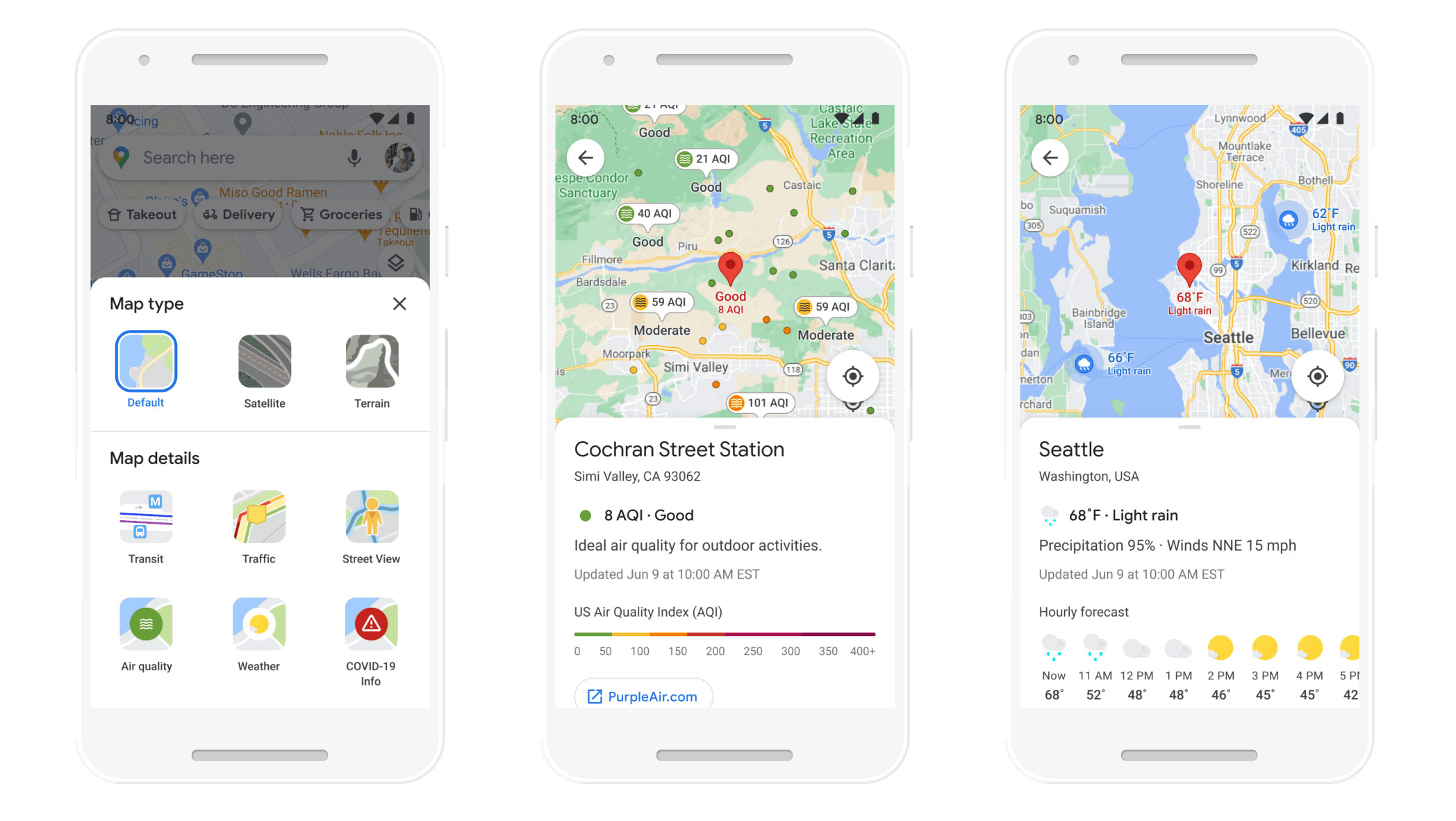
Along with this key feature, a number of other tools are finding their way to Google Maps, including map layers that provide information on current and forecast weather conditions for specific areas, as well as the air quality in an area (granted there's a nearby Air Quality Index [AQI] station).
The weather layer will roll out globally over the course of the year, and the AQI layer will be coming to the US, India and Australia.

For the environmentally-conscious Google Maps user, you'll soon be able to select a route based on lower fuel consumption and, as a result, lower carbon emissions. This will be calculated based on factors such as high density traffic and road incline.
In fact, Google Maps will default to choosing the more eco-friendly route when the alternatives "has approximately the same ETA," but you'll be given a prompt when it will take significantly longer. In either case, you'll be told how fewer emissions your trip will cause as a percentage.
This feature will land 'later this year' in the US on both Android and iOS, with other countries on the way.
From June, Google Maps will let you know if you'll be driving through low emission zones in global locations and cities that enforce them, and whether or not your vehicle is allowed in them. This feature will be coming to Germany, Netherlands, France, Spain and the UK, with more to follow.
Google is also making the choice between sustainable transport options easier to access with a singular screen within Maps that quickly summarizes all the different modes of transit to your destination and the time they'll take.
This feature will also learn from your habits and location to prioritize certain suitable options higher in the list – you can select your preferred methods manually, but biking options will be preferred if you cycle often, similarly with public transport. This feature is rolling out globally 'in the coming months'.
A number of other features will be coming to the iOS and Android app over the course of the year, including improvements to pickup and delivery details for participating grocery stores and service providers, as well as updates to Assistant Driving Mode.
- Google Pixel 5 review: a compact, affordable flagship
from TechRadar - All the latest technology news https://ift.tt/3wd1g7k

No comments:
Post a Comment